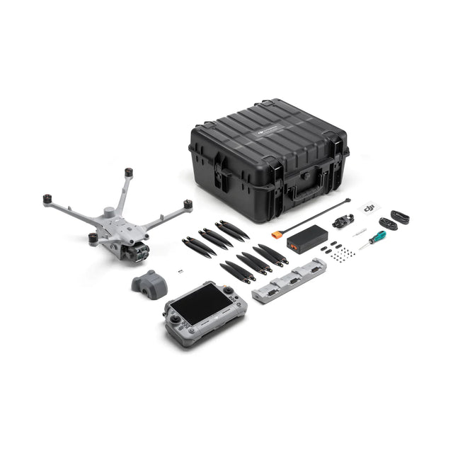
DJI Matrice 4TD
DJI Matrice 4TD – Advanced Thermal Imaging & Precision Aerial Intelligence
Unrivaled Durability, Thermal Imaging, and AI-Powered Flight
The DJI Matrice 4TD is an industrial-grade, water- and dust-resistant drone engineered for thermal imaging, high-precision mapping, infrastructure inspections, and public safety applications. Designed to integrate with DJI Dock 3 for fully autonomous remote deployment or operate independently with the DJI RC Plus 2 Enterprise, this drone delivers cutting-edge aerial intelligence with superior imaging capabilities.
Key Features
✅ Extended Flight & Durability – Up to 47 minutes of flight time with an IP55 rating for reliable operation in extreme conditions.
✅ Advanced Multi-Sensor System – Features a wide-angle, medium tele, and tele camera, along with an integrated Laser Range Finder and Infrared Thermal Camera for high-precision imaging.
✅ Infrared Thermal Camera – 640×512 resolution, f/1.0 aperture, Uncooled VOx Microbolometer, and UHR Infrared Image mode for highly detailed thermal imaging.
✅ Laser Range Finder – Provides an 1800m measurement range, ensuring accurate distance calculation for detailed inspections.
✅ NIR Auxiliary Light – Enhances nighttime and low-light operations with a 100m illumination distance.
✅ Advanced Obstacle Avoidance – Uses rotating LiDAR and millimeter-wave radar (sold separately) for 12mm wire-level obstacle detection, ensuring safe flight in complex environments.
✅ Extreme Weather Resilience – Withstands temperatures from -30°C to 50°C and wind speeds up to 12 m/s for year-round reliability.
✅ Standalone or Dock - Integrated Use – Operate manually with DJI RC Plus 2 Enterprise or deploy autonomously via DJI Dock 3.
✅ Long-Range Data Transmission – Seamless operation up to 25 km when paired with the D-RTK 3 Relay (sold separately).
Optimized for Precision Mapping & Inspections
The Matrice 4TD excels in thermal inspections, digital twin creation, and geospatial mapping, offering 5-direction oblique photography and 3-direction orthophoto capture for industry-leading accuracy.
- Enhanced stabilization maintains crystal-clear images even at 10x zoom.
- Real-time terrain following ensures precise altitude adjustments for consistent mapping accuracy.
- Smart 3D capture streamlines photogrammetry and modeling applications.
Built for Industry Leaders
The Matrice 4TD enhances public safety operations by providing real-time thermal imaging for firefighting, search & rescue, and emergency response teams. In powerline and infrastructure inspections, it detects overheating components, electrical faults, and structural anomalies at a distance. For geospatial and aerial mapping, the high-resolution sensors and automated route planning ensure precise topographic surveys.
The oil, gas, and renewable energy industries benefit from AI-driven flight automation for monitoring industrial assets, while nighttime and low-light operations are enhanced with the NIR auxiliary light and infrared thermal imaging. Additionally, its auto-relay system (sold separately) allows extended-range operations in mountainous or remote areas, making it ideal for disaster response, security surveillance, and industrial monitoring.
Paiement et sécurité
Méthodes de payement
Vos informations de paiement sont traitées de manière sécurisée. Nous ne stockons pas les détails de votre carte de crédit et n'avons pas accès aux informations de votre carte de crédit.