Autel Evo MAX 4N
$15,658.00 CAD
Unit price
/
Unavailable
The Autel EVO Max 4N is the next generation of intelligent, agile drones, equipped with 720-degree obstacle avoidance and A-Mesh 1.0 networking support. This commercial drone is designed for night operations, featuring starlight night vision, zoom, thermal cameras, and full laser ranging capabilities. The EVO Max 4N's exceptional starlight camera allows it to operate in lighting conditions as low as 0.0001 Lux, delivering unparalleled performance in the dark. This makes it ideal for night surveys, emergency responses, and other critical missions that require superior visibility. With its advanced features and capabilities, the Autel EVO Max 4N is the ultimate night-ops-ready drone for commercial applications.
Autonomous Path Finding
The Autel EVO Max 4N is powered by Autel's advanced Autonomy Engine, which collects surrounding environmental data and plans 3D flight paths through complex environments like mountains, forests, and buildings. This drone is ideal for a wide range of commercial applications, including rapid 3D scene reconstruction, public safety overwatch, industrial inspection, and land surveying.

Navigation in GPS Denied Environment
Advanced sensors allow the EVO Max 4N to navigate within hardened structures, underground, or in environments without GPS.

Accurate Object Identification and Tracking
The EVO Max 4N uses Autel's AI recognition technology to automatically identify and lock onto different types of targets such as heat sources, moving people, or vehicles. This enables the drone to achieve high-altitude tracking and data collection for law enforcement and other applications where reliable, real-time surveillance is crucial.

ULTIMATE OBSTACLE AVOIDANCE
The EVO Max 4N is a unique commercial drone that combines traditional binocular vision systems with millimeter-wave radar technology. This innovative combination enables the onboard Autel Autonomy Engine to detect objects as small as 0.5 inches, removing blind spots and allowing for operation in low light or rainy conditions.
Anti Jam, Anti Interference
The EVO Max 4N is equipped with advanced flight control modules and algorithms that are specifically designed to counter RFI, EMI, and GPS spoofing. This feature allows the drone to fly confidently near power lines, critical structures, and in complex areas, making it an ideal tool for industrial inspections, emergency response, and other critical operations.
Weather Rating-IP43
The EVO Max 4N has an IP43 Ingress Protection rating, which means that it is protected against solid objects greater than 1mm in diameter and against sprays of water up to 60 degrees from the vertical. This makes the drone more durable and able to withstand challenging weather conditions, making it ideal for use in a wide range of applications.
Operation Temperature
-4 ℉ TO 122 ℉

PLATFORM CAPABILITY
EVO Max 4N redefines portability with its powerful platform and all-weather design.
42 mins Max. Flight Time
23,000 ft Service Ceiling
12.4 miles Image Transmission Range
27 mph* Max. Wind Resistance
23,000 ft Service Ceiling
12.4 miles Image Transmission Range
27 mph* Max. Wind Resistance
HOT-SWAPPABLE BATTERY
The Autel EVO Max 4N features a hot-swappable battery system, allowing for extended flight times without any downtime. This innovative system enables users to easily swap out batteries while the drone is still in operation, thereby ensuring that there is no interruption to operations and making it ideal for use in time-critical applications where every second counts.
8070 mAh Capacity
14.88V Voltage
LiPo 4S Battery Type
120wh Energy
520g Net Weight
Support Hot Swap
14.88V Voltage
LiPo 4S Battery Type
120wh Energy
520g Net Weight
Support Hot Swap
EVO Max 4N is the only commercial drone that combines traditional binocular vision systems with millimeter wave radar technology, which enables the onboard Autel Autonomy Engine to detect objects as small as 0.5 inch, effectively eliminating blind spots and allowing operation in low light or rainy conditions.
Binocular Vision System
Millimeter Wave Radar
A-MESH 1.0
THE DRONE INDUSTRY'S FIRST MESH NETWORKING TECHNOLOGY
EVO Max 4N features the new A-Mesh system, enabling drone-to-drone autonomous communication, connection, and collaboration.
Strong Anti-Interference
Beyond-Line-of-Sight Applications
Full-Fleet Control
Enhanced Range
AUTEL SKYLINK 3.0
The EVO Max 4N SkyLink 3.0 system comes with 6 antennas, 4 frequency bands, AES-256 encryption*, and optional 4G integration* to provide users with the most advanced flight capabilities ever in an EVO.
12.4 miles Image Transmission Distance
<150ms Latency
1080p/60fps Real-Time Image Quality
900MHz/2.4GHz/5.2GHz/5.8GHz** Frequency Bands
<150ms Latency
1080p/60fps Real-Time Image Quality
900MHz/2.4GHz/5.2GHz/5.8GHz** Frequency Bands
This feature will be available in a future update. **5.2GHz is only applicable for FCC, CE, and UKCA regions. 900MHz is only applicable for FCC regions.
MISSION READY PAYLOAD
The payload integrates a wide-angle camera, zoom camera, thermal camera, and a laser rangefinder for all data capture needs and critical decision-making.
As low as 0.0001 Lux operate in lighting conditions
Auto ISO100-ISO450000 Super Sensitive Mode
50MP Wide Camera
1/1.28 CMOS Wide Camera Sensor
640x512 Thermal Resolution
5m to 1.2km Laser Rangefinder Measuring Range
Auto ISO100-ISO450000 Super Sensitive Mode
50MP Wide Camera
1/1.28 CMOS Wide Camera Sensor
640x512 Thermal Resolution
5m to 1.2km Laser Rangefinder Measuring Range

CHASE THE HEAT AND EXPLORE THE NIGHT
Starlight Camera(4N)
Super Zoom
Supersensitivity
Strong Infrared Perception
Accurate Ranging
AUTEL ENTERPRISE APP PLATFORM
The Autel Enterprise App has been specifically designed for industrial applications, with a brand-new interface that streamlines operation and enhances usability. With additional features and semi-autonomous modes, the app maximizes the EVO Max 4N's mission capability, enabling efficient and effective operation in a wide range of scenarios.

SMART FEATURES
3D Map Planning
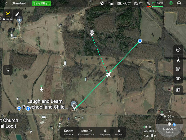
Plan, create, and execute 3D waypoint mission plan on a 3D map.

Quick Mission
Temporary quick missions can be created while executing other missions, and multiple sub-missions can be stacked for enhanced flexibility
Mission Reproduction
With this feature activated, fly a manual or semi-autonomous mission, or string multiple missions together. The EVO Max4N will automatically record the camera angles and replicate the mission you just flew.

MULTIPLE MISSION TYPES
The Autel Enterprise App offers a range of autonomous and semi-autonomous mission planning capabilities for a variety of applications, including public safety, inspection, and surveying.
Spiral Mission
Supports helical flight search in a designated area for SAR.

Vertical Scan
Perform vertical surveys for building facades, open pit walls, and towers.

Corridor Mission
Supports intuitive and effective corridor mission planning for roads, rivers, pipelines, power lines, and other narrow, large-scale terrain.

Polygon Mission
Supports one-click automatic generation of polygon flight areas.

Terrain Follow
Maintain a relatively constant altitude from the ground for uneven or sloped terrain.

Rectangular Mission
Supports one-click automatic generation of a rectangular flight area.

DATA SECURITY
Privacy Protection: Data involving user and aircraft information, including flight logs, locations, and account information can only be physically accessed via the aircraft locally.
Encrypted Data Storage: Supports AES-256 encryption for photos, videos, and flight logs, which are password-protected.

ENHANCED LIVE-VIEW
Multi-channel Projection Screen*
Supports simultaneous output of RGB, infrared, night vision, and wide-angle images.

AR Scene*
Geo-location data and other aircraft location info detected by ADS-B can overlay on a real-time map, which is convenient for users to confirm the drone's location and avoid airborne risks.

COMPLETE REMOTE OPERATIONS SYSTEM
Used with the EVO Nest, the EVO Max series supports all-weather autopiloting for scenarios such as substations, industrial parks, and rooftops.
AUTEL SDK
The Autel SDK is open to the world, helping developers and partners reduce software and hardware development costs and jointly create a new industry ecosystem.
-
Mobile SDK - Open UX SDK (iOS/Android) can directly call up the ready-made interactive interface.
Payment & Security
Payment methods
Your payment information is processed securely. We do not store credit card details nor have access to your credit card information.